User Guide
The Fish Resource Monitor is a geographic information system (GIS) that presents a variety of data available to the public through an interactive map covering the lands and waters of Alaska. It combines simple tools to locate places and identify features with fish stream and lake information found in the Anadromous Waters Catalog (AWC), culvert and barrier data from the Fish Passage Improvement Program (FPIP), and species sample sites which comprise the Alaska Freshwater Fish Inventory (AFFI)
.Data sets that are accessible through the Fish Resource Monitor are not exhaustive inventories, but are compilations of existing knowledge from field biologists that are subject to change at any time. When conducting projects or planning for permits involving fish and wildlife, please consider using additional information gathered from field investigations and consultations with ADF&G or other professional biologists.
Overview
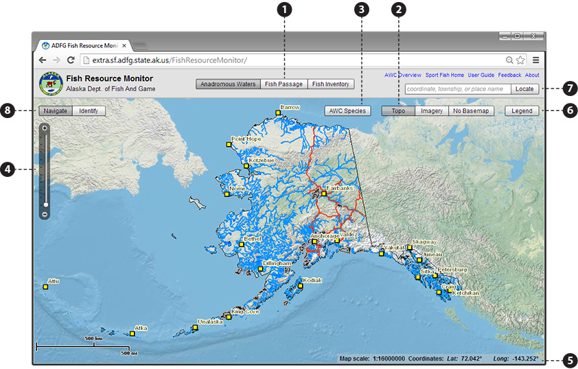
The Fish Resource Monitor application interface is split into a header and map display as pictured below. Use the blue links in the header to view a summary of ADF&G programs, go to the Sport Fish division web page, access this guide, or to provide feedback to ADF&G.
The content of the map display changes based on the following:
- Use the perspective button bar
 to select which data set features you want to
work with:
to select which data set features you want to
work with:
- Anadromous Waters:
- Nomination points along protected streams and lakes found in the Anadromous Waters Catalog.
- Fish Passage:
- Culvert and barrier sites tracked by the Fish Passage Improvement Program.
- Fish Inventory:
- Species sample sites which comprise the Alaska Freshwater Fish Inventory.
- The base map button bar
 switches the type of map displayed beneath the features
shown for the selected perspective:
switches the type of map displayed beneath the features
shown for the selected perspective:
- Topo:
- High quality relief map of Alaska.
- Imagery:
- Aerial imagery.
- No Basemap:
- Simple outline map of the Alaskan land mass.
- The AWC Species button
 allows you to highlight the presence of a specific fish
species on the map by life stage. Your species / life stage selection will appear in magenta on top of corresponding AWC streams and lakes.
allows you to highlight the presence of a specific fish
species on the map by life stage. Your species / life stage selection will appear in magenta on top of corresponding AWC streams and lakes.
This menu is also used to look up species codes (found in the species attribute of the AWC points).
- A map Legend
 is available to display meanings for the various symbols used.
Map Navigation
Navigating the map works similar to other online map services you may have used.
- Panning (re-centering) the map is always available by holding down your mouse button on the map and dragging in the desired direction.
- Use the zoom palette
 , located at the top left of the map display, to change map scale.
You can also change the scale at any time by rolling your mouse wheel, or holding the SHIFT-key while dragging a box on the map to
zoom to a specific area.
, located at the top left of the map display, to change map scale.
You can also change the scale at any time by rolling your mouse wheel, or holding the SHIFT-key while dragging a box on the map to
zoom to a specific area. - The current map scale and the coordinates of your mouse cursor are displayed continuously in the status panel
 .
.
Finding places
The Fish Resource Monitor can assist you with finding specific places in Alaska by using the Locate input box  located on the right-side of the header. You can enter a variety of different specifiers into the box, including:
- Latitude/longitude coordinate: Enter latitude followed by longitude, separated with a comma (i.e. 61,-154). Decimal degrees, decimal minutes, or degrees minutes seconds are all acceptable.
- Townships: Enter in standard PLSS meridian, township, range format (i.e. S012N004W), or in short format (i.e. S12N4W).
- Well-known place name: You may enter town names, road names, AWC stream names, AWC stream codes, USGS topo names, and USGS HUC4/HUC5 codes. For town/road/stream names, suggestions are shown based on what you've typed so far.
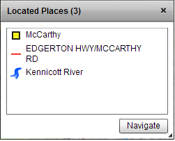 When you find a place, the map will pan/zoom to its location and it will be listed in the Located Places panel. The Located Places panel appears the
first time you locate a place, and it serves both as a history of places you've referenced in your session and also as a navigation tool. All places
you find are listed in most recent order.
When you find a place, the map will pan/zoom to its location and it will be listed in the Located Places panel. The Located Places panel appears the
first time you locate a place, and it serves both as a history of places you've referenced in your session and also as a navigation tool. All places
you find are listed in most recent order.
Each type of place is indicated with a different icon to help you distinguish between different types of place features having the same name (e.g. Eagle River is the name of a town, an AWC stream, and a USGS HUC5 watershed).
You can navigate back to a previously located place by selecting it and pressing the Navigate button, or by double-clicking it. You can also navigate to a group of places by selecting each of them while holding SHIFT-key and then using the Navigate button or double clicking them.
Pro-tip: You can right-click anywhere on the map and select options from the context menu to add the current mouse position to the Located Places panel or to copy a latitude/longitude coordinate to the clipboard for use outside the application.
Identifying Features
You can get more information about features shown on the map by "identifying" them. Select Identify in the tool button bar
 to enable feature identification.
- Click on a feature shown on the map to get detailed information associated with it.
- The Identify Panel will appear indicating lat/long coordinate of the point you clicked clicked as well as how many features were found.
- Click on a feature in the panel to see its attribute information. Some features such as AWC Points and streams, AFFI survey points, and FPIP culverts will have a View button that links to detailed reports or other information found on the ADF&G web site.
- Double clicking on a feature listed in the Identify Panel will pan/zoom the map to that feature and highlight it.
Searching (only available when displaying AFFI data)
- Allows selection of AFFI survey points by fish species and/or survey project. Highlights and zooms map to selected features. In the search grid users can click on single records to highlight the corresponding point on the map.
Questions or comments about this guide can be directed to dfg.dsf.webmaster@alaska.gov