| STATEWIDE: | Contact Us |
|
Anadromous Waters Catalog (AWC) - Maps Draft versions of the AWC maps will be available online for in-house review until further notice. Only those maps listed are available for review. To locate a map (PDF format), select on one of the six regions. The list of updated maps available for viewing from the selected quad will be displayed. Listed Atlas maps utilize a 3 character USGS abbreviation for each map quad name (i.e., ADAK A-3 would be listed as ADAA3.pdf). Once you have located your map, save the file to your computer by right-clicking on the link. Bear in mind that these PDF files are quite large (several Megabytes) and download speed will vary with connection speed. Click on the map to select a region.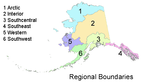 As you review the updated maps it is important to remember that only changes made by submission of a nomination or obvious errors such as misspellings are subject to editing during the review process. The purpose of the review is to allow all concerned parties an opportunity to review changes they submitted to ensure that changes were drafted accurately. Personnel will also be able to review changes made by personnel at other offices for concurrence. ADF&G personnel that have submitted nomination forms for this regulatory update will receive an email that lists the Atlas maps that they have submitted nominations forms for. To help you find the map(s) you are interested in, the following RTF files list: Maps are available in three scales: 1:250,000, 1:63:360, and 1:25,000. The 1:250,000 quad maps cover an entire quad (i.e. Arctic) at that scale. The 1:250,000 scale index maps depict the boundaries of 1:63,360 scale quads (i.e. Arctic A-1). The labeled 1:63,360 quads indicate that there are anadromous waterbodies in that quad. The 1:25,000 scale maps cover the northeast, southeast, northwest, and southwest quadrants of the 1:63,360 scale maps (i.e. Valdez A-7 SE). These maps were created to display a part of the map where there are a number of anadromous waterbodies in such a small area that it is difficult to distinguish individual rivers, streams, or lakes. The 1:63,360 scale maps display the anadromous waterbodies found in the quad. Contact J. Johnson if you have questions, require additional information, or identify errors that require correction.
|
 |
State of Alaska Home |
ADF&G Home |
Sport Fish Home |
Commercial Fish |
Wildlife Conservation
Sport Fish Division Webmaster: derek.hedstrom@alaska.gov |